images of Tibet
Travel-Images.com
Tibet / Tibete / Xizang / Bod - flag images of
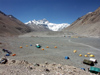
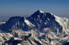
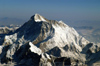
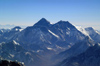
Tibet
(currently under PRC administration)
7 - Himalayas - Mount Everest, Mount Makalu
Page 1
page 2
page 3
page 4
page 5
page 6
Page 7
Tibet - Mount Everest: northern side of the mountain and the base camp in the valley - tents - the highest mountain on Earth - Chomolangma or Qomolangma or Sagarmatha - Xigazê Prefecture - photo by P.Artus Tibet - Mount Everest: northern side of the mountain and the base camp in the valley - tents - the highest mountain on Earth - Xigazê Prefecture Tibet - Mount Everest, southern slope - seen from the flight between Delhi and Paro in Bhutan - Tibet - Nepal border - Himalayas - Qomolangma / Sagarmatha / Chomolungma - photo by A.Ferrari Tibet - Mount Everest, southern slope - seen from the flight between Delhi and Paro in Bhutan - Tibet - Nepal border - Himalayas - Qomolangma / Sagarmatha / Chomolungma
Tibet - Mount Makalu / Makaru, seen from the flight between Delhi and Paro in Bhutan - Tibet - Nepal border - Himalayas - Xigazê Prefecture - photo by A.Ferrari Tibet - Mount Makalu / Makaru, seen from the flight between Delhi and Paro in Bhutan - Tibet - Nepal border - Himalayas - Xigazê Prefecture Tibet - Mount Everest, seen from the flight between Delhi and Paro in Bhutan - Tibet - Nepal border - Himalayas - photo by A.Ferrari Tibet - Mount Everest, seen from the flight between Delhi and Paro in Bhutan - Tibet - Nepal border - Himalayas
Page 1
page 2
page 3
page 4
page 5
page 6
Page 7
buy images image bank / agency
main
credits: photos © by A.Ferrari, P.Artus / Travel-Images.com
previous page (photos of Tibet) next page (photos of Timor Leste)
see also: India, China, Nepal, Bhutan, Myanmar (Burma), Cambodia, Sikkim, Asia
click on the thumbnails to enlarge the images - photos of Tibet - image bank - Bilder
images of Tibet by
www.travel-images.com