images of the USA
Travel-Images.com
Republic of California flag - United States of America / Estados Unidos / Etats Unis / EE.UU / EUA / USA- images of
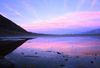
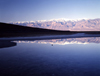
the USA
California
3 - Death Valley
AK
AL
AR
AZ
1
2
3
4
5
6
7
8
CA
CO
CT
DC
DE
FL
GA
HI
IA
ID
IL
IN
KS
KY
LA
MA
MD
ME
MI
MN
MO
MS
MT
NC
ND
NE
NH
NJ
NM
NV
NY
OH
OK
OR
PA
RI
SC
SD
TN
TX
UT
VA
VT
WA
WI
WV
WY
Death Valley National Park, California, USA: Joshua tree / Yucca palm, Yucca brevifolia - Mojave desert landscape - photo by M.Torres Death Valley National Park, California: Joshua tree / Yucca palm, Yucca brevifolia - Mojave desert landscape    Death Valley National Park, California, USA: Zabriskie Point - Manly Beacon, named after William L. Manly, who with John Rogers, guided ill-fated Forty-niners gold prospectors out of the valley during the 1849 gold rush - photo by M.Torres Death Valley National Park, California: Zabriskie Point - Manly Beacon, named after William L. Manly, who with John Rogers, guided ill-fated Forty-niners gold prospectors out of the valley during the 1849 gold rush 


Death Valley National Park, California, USA: bench at Zabriskie Point - named after Christian Brevoort Zabriskie,  general manager of the Pacific Coast Borax Company - Amargosa Range - photo by M.Torres Death Valley National Park, California: bench at Zabriskie Point - named after Christian Brevoort Zabriskie, general manager of the Pacific Coast Borax Company - Amargosa Range    Death Valley National Park, California, USA: Zabriskie Point - Manly Beacon, a rock formation that stands like a shark fin in the horizon - photo by M.Torres Death Valley National Park, California: Zabriskie Point - Manly Beacon, a rock formation that stands like a shark fin in the horizon 
Death Valley National Park, California, USA: view from Zabriskie Point - rugged terrain often used in motion pictures - erosional landscape - colorful clay and mudstone badlands at Furnace Creek - photo by M.Torres Death Valley National Park, California: view from Zabriskie Point - rugged terrain often used in motion pictures - erosional landscape - colorful clay and mudstone badlands at Furnace Creek    Death Valley National Park, California, USA: Zabriskie Point - alluvial fan - labirinth of wildly eroded and vibrantly colored badlands - photo by M.Torres Death Valley National Park, California: Zabriskie Point - alluvial fan - labirinth of wildly eroded and vibrantly colored badlands 
Death Valley National Park, California, USA: Zabriskie Point - undulating landscape of gullies and mud hills at the edge of the Funeral Mountains - photo by M.Torres Death Valley National Park, California: Zabriskie Point - undulating landscape of gullies and mud hills at the edge of the Funeral Mountains    Death Valley National Park, California, USA: Zabriskie Point - view towards Gower Gulch - the flat salt plains on the valley floor and the Panamint Range are visible in the distance - photo by M.Torres Death Valley National Park, California: Zabriskie Point - view towards Gower Gulch - the flat salt plains on the valley floor and the Panamint Range are visible in the distance 
Death Valley National Park, California, USA: view from Zabriskie Point - immortalized in film by Italian director Michelangelo Antonioni - colorful badlands - photo by M.Torres Death Valley National Park, California: view from Zabriskie Point - immortalized in film by Italian director Michelangelo Antonioni - colorful badlands    Death Valley National Park, California, USA: Devil's Golf Course - sign and halite salt crystal formations against the Panamint Range - photo by M.Torres Death Valley National Park, California: Devil's Golf Course - sign and halite salt crystal formations against the Panamint Range 
Death Valley National Park, California, USA: Devil's Golf Course -  rock salt eroded by wind and water into jagged spires - photo by M.Torres Death Valley National Park, California: Devil's Golf Course - rock salt eroded by wind and water into jagged spires    Death Valley National Park, California, USA: Badwater Basin - salt water at the lowest point in North America, 86 meters below sea level, a surreal landscape of vast salt flats - the wetlands are inhabited by rare snails - photo by M.Torres Death Valley National Park, California: Badwater Basin - salt water at the lowest point in North America, 86 meters below sea level, a surreal landscape of vast salt flats - the wetlands are inhabited by rare snails 
Death Valley National Park, California, USA: Badwater Basin along Badwater Road - salt flats - arid climate where evaporation exceeds precipitation, leaving behind just the salts and fine silt - photo by M.Torres Death Valley National Park, California: Badwater Basin along Badwater Road - salt flats - arid climate where evaporation exceeds precipitation, leaving behind just the salts and fine silt    Death Valley National Park, California, USA: Badwater Basin - sign and general view of the valley - looking North - Panamint Range on the left, Amargosa range on the right - photo by M.Torres Death Valley National Park, California: Badwater Basin - sign and general view of the valley - looking North - Panamint Range on the left, Amargosa range on the right 
Death Valley National Park, California, USA: Artist Drive - Amargosa Range - cone shaped hill - photo by M.Torres Death Valley National Park, California: Artist Drive - Amargosa Range - cone shaped hill    Death Valley National Park, California, USA: Artist Drive - Artist's Palette, an array of colors - red, yellow, violet, green, brown and black, the result of the oxidation of iron,copper, manganese and other minerals - photo by M.Torres Death Valley National Park, California: Artist Drive - Artist's Palette, an array of colors - red, yellow, violet, green, brown and black, the result of the oxidation of iron,copper, manganese and other minerals 
Death Valley National Park, California, USA: Artist Drive - Artist's Palette - colorful alluvial fan in the Amargosa Range - photo by M.Torres Death Valley National Park, California: Artist Drive - Artist's Palette - colorful alluvial fan in the Amargosa Range    Death Valley National Park, California, USA: Artist Drive - spectacular rocky landscape - sign and road at the loop's entrance - photo by M.Torres Death Valley National Park, California: Artist Drive - spectacular rocky landscape - sign and road at the loop's entrance 
Death Valley National Park, California, USA: Artist Drive - curvy, one-way, one lane road leading up to the edge of the Black Mountains - photo by M.Torres Death Valley National Park, California: Artist Drive - curvy, one-way, one lane road leading up to the edge of the Black Mountains    Death Valley National Park, California, USA: eroded slope on the Amargosa Range - photo by M.Torres Death Valley National Park, California: eroded slope on the Amargosa Range 
Death Valley National Park, California, USA:  Amargosa Range along Badwater Road - colorful hills - curved bands of clayish rock in vivid hues of green, white, pink and black - photo by M.Torres Death Valley National Park, California: Amargosa Range along Badwater Road - colorful hills - curved bands of clayish rock in vivid hues of green, white, pink and black    Death Valley National Park, California, USA: the largest national park in the U.S., encompasses some 3.3 million acres of the Mojave Desert - Panamint Range in the distance - photo by M.Torres Death Valley National Park, California: the largest national park in the U.S., encompasses some 3.3 million acres of the Mojave Desert - Panamint Range in the distance 
Death Valley National Park, California, USA: Artist Drive - asphalt and colorful hills - photo by M.Torres Death Valley National Park, California: Artist Drive - asphalt and colorful hills    Death Valley National Park, California, USA: Badwater Basin dry salt lake and the Amargosa range - looking south - photo by M.Torres Death Valley National Park, California: Badwater Basin dry salt lake and the Amargosa range - looking south 
Death Valley National Park, California, USA: Badwater Basin - vast field of salty terrain - photo by M.Torres Death Valley National Park, California: Badwater Basin - vast field of salty terrain    Death Valley National Park, California, USA: Badwater Basin dry lake - salt flats - pattern defined by salt ridges - Amargosa range - photo by M.Torres Death Valley National Park, California: Badwater Basin dry lake - salt flats - pattern defined by salt ridges - Amargosa range 
Death Valley National Park, California, USA: Zabriskie Point - badlands - water erosion produces bone-dry, finely-sculpted, golden brown rock - Furnace Creek Formation - alluvial fan - photo by M.Torres Death Valley National Park, California: Zabriskie Point - badlands - water erosion produces bone-dry, finely-sculpted, golden brown rock - Furnace Creek Formation - alluvial fan    Death Valley (California): prospector and penguin - art - sculpture - Photo by G.Friedman Death Valley (California): prospector and penguin
USA - Death Valley (California): sand dunes - desert - Mesquite Dunes - vale da morte - photo by J.Fekete Death Valley (California): sand dunes - desert - Mesquite Dunes Death Valley (California): the edge overlooking the Mojave desert - Photo by G.Friedman Death Valley (California): the edge overlooking the Mojave desert
Death Valley National Park, California, USA: Joshua tree / Yucca palm, Yucca brevifolia - monocotyledonous tree is native to southwestern North America - evergreen, stiff and dagger-like leaves - photo by M.Torres Death Valley National Park, California: Joshua tree / Yucca palm, Yucca brevifolia - monocotyledonous tree is native to southwestern North America - evergreen, stiff and dagger-like leaves  Death Valley (California): Joshua tree - Photo by G.Friedman Death Valley (California): Joshua tree
Death Valley (California): Emigrant pass at dawn - sign - photo by G.Friedman Death Valley (California): Emigrant pass Death Valley (California): Fencepost and Mountains - landscape - Photo by G.Friedman Death Valley (California): fencepost and mountains
USA - Death Valley NP - Mojave Desert (California): Rock Valley path - rock canyons near Stovepipe Wells - Photo by G.Friedman Death Valley NP (California): Rock Valley path - rock canyons near Stovepipe Wells USA - Death Valley National Park (California): Panamint Range - snowy peaks overlooking Death Valley - photo by J.Fekete Death Valley National Park (California): Panamint Range - snowy peaks overlooking Death Valley
USA - Death Valley (California): Badwater - sunrise with reflection of mountains - salt lake - the lowest point in western hemisphere - photo by J.Fekete Death Valley (California): Badwater - sunrise with reflection of mountains - salt lake - the lowest point in western hemisphere USA - Death Valley (California): Telescope Peak elev. 11049 ft overlooking the Badwater, -279 ft bellow sea level - photo by J.Fekete Death Valley (California): Telescope Peak elev. 11049 ft overlooking the Badwater, -279 ft bellow sea level
Note: Puerto Rico, USVI, Guam are shown on separate sections
 
AK
AL
AR
AZ
1
2
3
4
5
6
7
8
CA
CO
CT
DC
DE
FL
GA
HI
IA
ID
IL
IN
KS
KY
LA
MA
MD
ME
MI
MN
MO
MS
MT
NC
ND
NE
NH
NJ
NM
NV
NY
OH
OK
OR
PA
RI
SC
SD
TN
TX
UT
VA
VT
WA
WI
WV
WY
photos © by M.Torres, G.Friedman, J.Fekete / Travel-Images.com
main
image bank /  buy images
previous page (photos of the US)
next page (photos of the USA)
 
see also: Canada, Mexico, Puerto Rico, Hawaii, Colorado, England, Spain, France, Americas
click on the thumbnails to enlarge the images - photos of California - USA image bank - stock photography
images of the United States of America (US)
by
www.travel-images.com