
| Jebrail (Cebrayil, Dzhebrail) |
Azerb.com
|
Jebrail
is a small town situated at an altitude of 600m, in the southern foothills
of the Nagorno Karabakh mountain range. A stream, which flows through
the Jebrail, dries out in summertime. Until 1950 Jebrail was merely
a village but its population increased a lot in the following years.
It is the capital of the rayon of the same name with a territory of 1050
sq. km., separated from the Iranian province of Eastern Azerbaijan by the
river Araz. In the pre-Soviet period the present area of the district was
part of the Jabrail uyezd, formed in 1875, which was even larger.
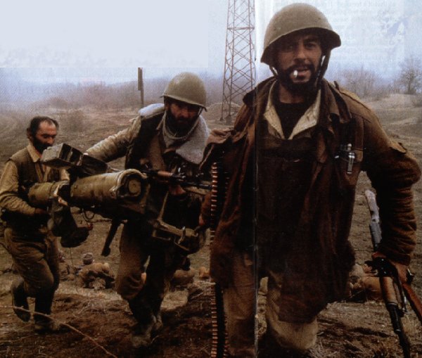
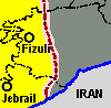 After
the fall of Fizuli to Armenian forces, Jebrail
and almost the entire rayon were lost to Armenian forces in August 26,
1993 and has been under Armenian military control ever since (see map).
After
the fall of Fizuli to Armenian forces, Jebrail
and almost the entire rayon were lost to Armenian forces in August 26,
1993 and has been under Armenian military control ever since (see map).
The railway built along the Araz, that once connected Baku to Nakhchivan now lies abandoned, on the other hand the road parallel to both the river and the railway is still important, carrying the traffic to Armenia and Iran.
 The
population of Jebrail had to move eastwards, and today is spread all over
Azerbaijan, to this day some still dwell in refugee
camps.
The
population of Jebrail had to move eastwards, and today is spread all over
Azerbaijan, to this day some still dwell in refugee
camps.
Jebrail borders the Nagorno Karabakh territory but is not claimed by the Armenians, as such it is currently occupied as part of their 'buffer zone' and left derelict and abandoned. The town has been cannibalized for all kinds of materials by both Armenians and Iranians. In pre-war times the area earned their living from cash-crops, in particular cotton - dubbed by the locals the "white gold" of Azerbaijan.
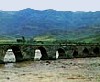 The
most picturesque scenery in the vicinity is a huge poplar (tulip tree),
which is believed to be one thousand years old. Outside Jebrail, in the
village of Khalfli, an ancient watch tower still stands, allowing
a great panorama over the region. The ruins of two remarkable 12th century
bridges can be seen in the village of Khudafarin.
The
most picturesque scenery in the vicinity is a huge poplar (tulip tree),
which is believed to be one thousand years old. Outside Jebrail, in the
village of Khalfli, an ancient watch tower still stands, allowing
a great panorama over the region. The ruins of two remarkable 12th century
bridges can be seen in the village of Khudafarin.
(340 km south-west of Baku)
| see also: places, maps, Fizuli, Zangilan, Xankandi,Qubadli, Nagorno-Karabakh, Nakhchivan, summary, images |
| A to Z of Azerbaijan / A dan Z ye Azerbaycan |
www.azerb.com
|