
| Zangilan (Zangelan, Kovsakan) |
Azerb.com
|
Zangilan
is the capital of a wedged shapped rayon (district), bordering both Armenia
and Iran. The rayon covers an area of 707 sq. km and was established in
1930. The district of Zangelan covers mainly the area between the lower
courses of the Voghji, Tzav (or Basur) and Hakari rivers.
The town of Zangilan was an small village untill 1957, when it was turned to a 'town type settlement' and later - in 1967 to a 'town of republican significance' with many inhabitants being moved to the area.
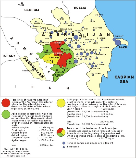
Zangilan and the entire rayon were lost to Armenian forces in 1993 and have been under Armenian control ever since. The railway built along the Araz, that once connected Baku to Nakhchivan is now abandoned, the road parallel to both the river and the railway carries the traffic to Armenia and Iran. The population of Zangilan had to move eastwards, and today is spread all over Azerbaijan, to this day some still dwell in refugee camps.
 The
entire district in general and specifically the areas adjoining the Araxes
riverside, have always been reputed by their warm climate. Describing the
10 years that Vasak the Hermit passed in this province, St. Orbelian noted
that he had been living on fruits and other produce of earth, as soon as
"summers and winters in this land resembled those of Egypt." In pre-war
times the area earned their living from agriculture with a population of
almost 30.000, mostly Azeris and Kurds - after
1950 the Armenian population slowly diminished and eventualy the numbers
became residual.
The
entire district in general and specifically the areas adjoining the Araxes
riverside, have always been reputed by their warm climate. Describing the
10 years that Vasak the Hermit passed in this province, St. Orbelian noted
that he had been living on fruits and other produce of earth, as soon as
"summers and winters in this land resembled those of Egypt." In pre-war
times the area earned their living from agriculture with a population of
almost 30.000, mostly Azeris and Kurds - after
1950 the Armenian population slowly diminished and eventualy the numbers
became residual.
In the Middle Ages the district was known under the name of the fortress Grham. There were 53 villages in the district. Grham, after which the whole area was later named, was one of the main strongholds of the area and played an important role over the whole period of existence of the Syunik principality (821-987 AD) and later - Syunik kingdom (987-1170 AD). During the XVII-XVIII centuries Kovsakan or Grham divided to minor administrative entities.
Most of the historical monuments are situated closer to the borderline of the Republic of Armenia, in the western - mainly mountainous parts of the region, frequently covered with forests. Many Armenian churches still survive as well as monasteries and a fortress in the extreme soth-west of the rayon.
Zangilan does not border the Nagorno Karabakh territory and is not claimed by the Armenians, as such it is currently occupied as part of their 'buffer zone' and left derelict and abandoned. The town has been cannibalized for all kinds of materials by both Armenians and Iranians.
In the present cold peace climate, in order to reach Zangilan you must go trough Armenia. This should not be very difficult as the Nagorno-Karabakh (Artsakh for the Armenians) region is eager to welcome tourists. See the section on visas, for details.
(380 km south-west of Baku)
| see also: places, maps, Kurdish, Jebrail, Fizuli, Xankandi, Nagorno-Karabakh, Nakhchivan, summary, images |
| A to Z of Azerbaijan / A dan Z ye Azerbaycan |
www.azerb.com
|